


Plagne Bellecote - Les Croyants - Plagne bellecote

nave
User
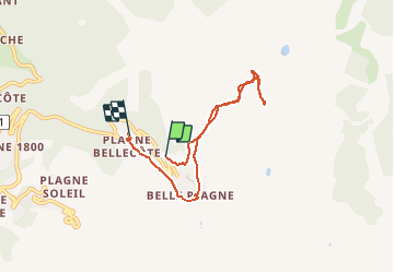

Length
6.5 km

Max alt
2369 m

Uphill gradient
359 m
Km-Effort
11.5 km

Min alt
1927 m

Downhill gradient
435 m
Boucle
No
Creation date :
2021-03-13 10:28:56.756
Updated on :
2021-03-13 13:47:39.841
3h00
Difficulty : Medium

FREE GPS app for hiking
 SityTrail
IGN / Geographical institutes
SityTrail Plus
The world is yours!
About
Trail Touring skiing of 6.5 km to be discovered at Auvergne-Rhône-Alpes, Savoy, La Plagne-Tarentaise. This trail is proposed by nave.
Description
Ballade à ski de randonnée depuis Bellecote . Arrivée Crozats descente vers Belle Plagne (un mojito et une gaufre) puis retour Bellecote
Positioning
Country:
France
Region :
Auvergne-Rhône-Alpes
Department/Province :
Savoy
Municipality :
La Plagne-Tarentaise
Location:
Mâcot-la-Plagne
Start:(Dec)
Start:(UTM)
320597 ; 5042336 (32T) N.
Comments